43rd Katoa Po Night Relay - 11 March 2023
Bulletin 2
Event Info
When - Saturday 11th March 2023
- 4:00pm Campsite opens
- 5:30pm Registration opens
- 6:30pm return Team lists with names in running order
- 7:00pm Briefing for all competitors
- Relay Starts at Dusk
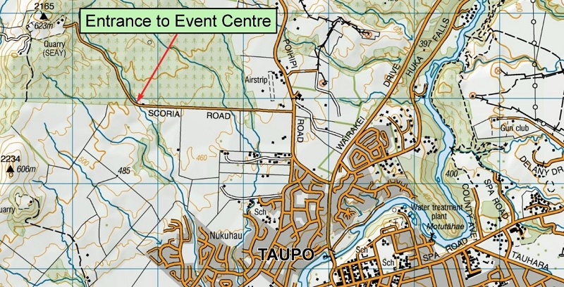
Where - Scoria Road off Poihipi Road, Taupo
Organiser - Taupo Orienteering Club
Planner - Robert Newbrook
Controller - Sue Newbrook
Registration: - Online
Entry Deadline - Tuesday, 28th February 11:59pm
Individuals enter the event online via entero. The clubs will be sent a list of competitors from which they will
allocate the legs, according to the eligibility criteria below.
• enquiries to entries@taupoorienteering.nz
Courses - see below.
Entry fees per team
- 7 person team $245
- 5 person team $175
- 5 all juniors team $135 (born 2003 or later)
What - The premier night orienteering competition in New Zealand. This night relay for 5 and 7 person teams runs deep into the night. The relay starts about dusk with a mass start for the white course. It progresses to harder and longer courses. The final two legs are mainly for elite runners.
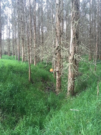
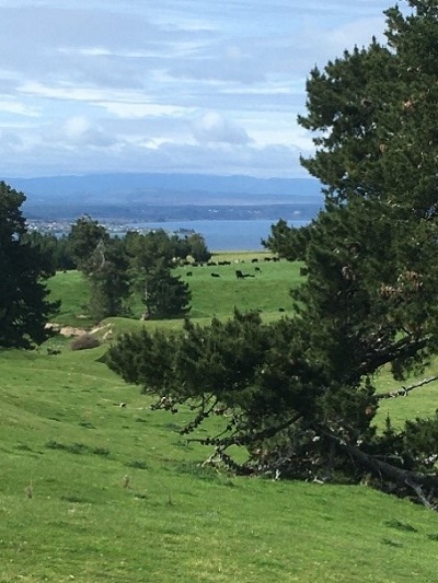
The Terrain - The event is on the Scoria Road map, last partly used in 2020. It has areas of farm with rolling hills and erosion gullies along with pine, eucalypt and manuka forest.
Eligibility -
| Course | Grade restrictions | ONZ Colour Code |
|---|---|---|
| Leg 1 | No M14A-70A, No W16A-65A (All B grades allowed) | White |
| Leg 2 | No M16A-60A, No W18A-55A (All B grades allowed) | Yellow |
| Leg 3 | No M18A-55A, No W20A-35A (All B grades allowed) | Orange |
| Leg 4 | No M20A-45A, No W21E | Orange/Red |
| Leg 5 | No M21E (allowed if last leg of 5 person team) | Red |
| Leg 6 | Open | Red |
| Leg 7 | Open | Red |
• Exemptions to the above rules will be considered on their merits by the controller. The essential essence of the competition is fairness. The controller will use this as the guiding principle for determining if nominally ineligible runners can drop down a leg.
Estimated Winning Times -
- Leg 1 - 2.2km 15 minutes, median time 25 minutes (white)
- Leg 2 - 3.0km 22 minutes, median time 35 minutes (yellow)
- Leg 3 - 4.0km 30 minutes (orange)
- Leg 4 - 4.9km 40 minutes (orange/red)
- Leg 5 - 5.8km 50 minutes (red)
- Leg 6 - 7.2km 50-55 minutes (red)
- Leg 7 - 8.3km 60-65 minutes (red)
Special Rules -
- Every team finishes, so there are no DSQs.
- A missed punch incurs a time penalty of the slowest time for that leg (of the 5 person or 7 person teams as appropriate) plus 15 minutes.
- DNF's are the slowest time for that leg (when all the other penalties are added in) plus a 15 minute penalty. Placing's are determined solely by time, including penalties.
- Deliberate manipulation of the rules, eg having an overseas W21E running Leg 4, can incur additional penalties at the discretion of the controller.
- Family and composite teams will be allowed but are not eligible for the winner's trophies
SPORTident - To allow for smooth organization and cater for the inevitable last minute
changes all teams will be issued with a set of SI cards allocated to each leg.
It is imperative that these cards are given to the appropriate leg.
Some notes from the Course Planner -
- The optimum routes of courses 3 to 7 will pass near/through the camping/registration/warm-up/start/finish area, at least once.
- Course 3 to 7 have a map flip and controls in the forested area.
- The forest is principally maturing pine with small areas of both gum & Manuka.
- Run-ability in the forest is generally good although zig-zagging will be required.
- Visibility is from park-like under the gums to about 10 meters in the Manuka with the pine varying between these 2 extremes.
- Approximately 50% of the controls/course lengths on courses 5 to 7 are in the forested area.
- Fences will be shown on all maps. Gates are shown as gaps in the fence with additional crossing shown use the crossing point symbol. Electric fence will be off.
- Fences in the forested area are in varied condition from stock-proof to all but invisible and fragile.
- The farmland is considered generally fast running, bisected with fences.
- New/unmarked Tomos (sink holes) are very rare but caution is advised when traversing along the floor of the gullies.
- Lastly, all the usual forest & farmland hazard can be found on this map (fences, barbed wire fences, thistles, blackberry, uneven ground, earth banks, small cliffs, tree litter, sharp pointy branches, both fast moving and stationery lost! Orienteers).
Camping Facilities
Access via a Farm Track. Maybe tricky if wet or for very large Motorhomes, caravans or trailers.
Great views, Portaloos, bring your own water (some water will be available for competitor hydration).
No fires or pets allowed.
Event Location
From Wairakei Dr turn onto Poihipi Rd (signs for Kinloch/Mangakino/Te Kuiti/Great Lake Trail)
After 2 Km - turn left on to Scoria Road (Private road to Seays quarry)
After 2 Km - turn left on to farm track to Event Centre